
Tornado Watch issued for all of southeast Wisconsin
Watch is in effect until 6 p.m.
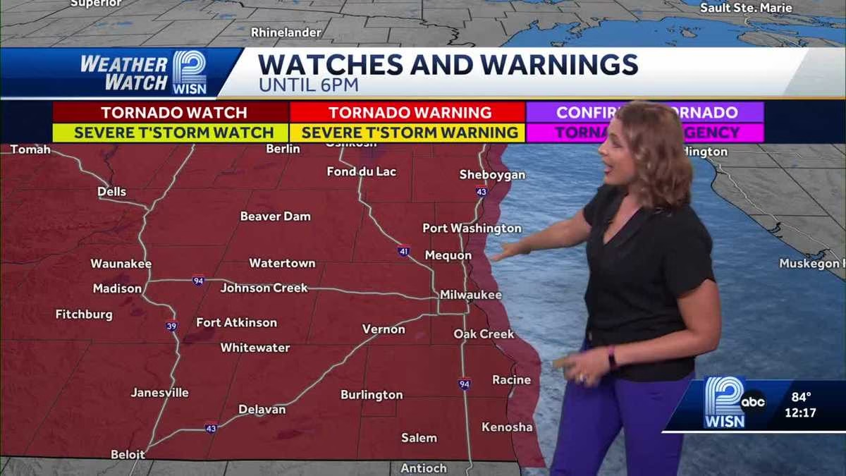
TO SEE WHY. WEATHERWATCH 12. THIS IS A SEVERE WEATHER UPDATE. HELLO, I’M METEOROLOGIST LINDSEY SLATER. WE DO HAVE A SEVERE WEATHER UPDATE I WANT TO LET YOU KNOW ABOUT. WE HAVE A TORNADO WATCH THAT HAS NOW BEEN ISSUED ACROSS ALL OF SOUTHERN WISCONSIN. THIS DOES INCLUDE MILWAUKEE COUNTY, WAUKESHA AND EVERYBODY YOU SEE HERE IN THE RED. AGAIN, IT IS A TORNADO WATCH, NOT A TORNADO WARNING. THIS IS DUE TO THOSE SHOWERS AND THUNDERSTORMS THAT I HAVE BEEN TRACKING ALL MORNING LONG. YOU CAN SEE THEM RIGHT HERE POPPING UP ON THE RADAR. AND THERE ACTUALLY IS A TORNADO WARNING IN EFFECT FOR IOWA COUNTY. SO THIS IS THE LINE THAT’S PUSHING ITS WAY TO THE NORTH AND EAST, AND THERE IS SOME ROTATION. THERE’S TONS OF ENERGY IN THE ATMOSPHERE FOR THIS TO PLAY WITH, WHICH IS WHY WE ARE SEEING THIS ACTIVITY REALLY START TO POP UP. SO WE’RE GOING TO BE WATCHING THIS LINE OF STORMS. IT WILL CONGEAL WITH THE MAIN EVENT THAT’S STILL COMING THROUGH BETWEEN 3 AND 7:00. SO A LIVE LOOK HERE IN DELAVAN, YOU CAN SEE THOSE CLOUDS ARE STARTING TO PICK UP RIGHT NOW. AND I HAVE A LOOK HERE AT OCONOMOWOC. TEMPERATURES ARE IN THE LOW AND MID 80S ACROSS THE BOARD. SO THE 12 HOUR FORECAST YOU CAN SEE I HAVE THESE LITTLE ALERT ICONS UP HERE BECAUSE THE TEMPERATURES ARE IN THE LOW AND MID 80S. WE WILL SEE POP UP THUNDERSTORMS THROUGH AT LEAST 3:00. AND THEN WE’LL GET THAT BIG LINE OF STORMS ARRIVING BETWEEN 3 AND 7:00. REMEMBER, ALL MODES OF SEVERE WEATHER ARE POSSIBLE. THIS INCLUDES DAMAGING WINDS, ISOLATED TORNADOES. WE COULD SEE THOSE WINDS GUSTING UP TO 70 MILES AN HOUR. HEAVY DOWNPOURS, AND ALSO A LOT OF LIGHTNING. WE’LL BE BACK HERE WITH ANY ADDITIONAL UPDATES COM
Tornado Watch issued for all of southeast Wisconsin
Watch is in effect until 6 p.m.

A tornado watch is in effect for all of southeast Wisconsin.Interactive RadarThe watch is in effect until 6 p.m. Storms are expected to move into the western counties, such as Jefferson County, as early as 3 p.m. Severe weather is most likely along the leading edge of the line. Primary threats include tornadoes, scattered damaging wind gusts up to 70 mph and isolated large hail up to 1 inch in diameter. Storms are forecast to move east and out over Lake Michigan before 8 p.m.A tornado watch means conditions are favorable for tornadoes and severe thunderstorms in and close to the watch area. Top HeadlinesRecovery effort underway for teen at Jaycee Quarry Park in SheboyganFranklin Walmart fire started by 10-year-old boy closes store indefinitelyUncle of abducted Milwaukee boy charged with firing shots at carWATCH Steel beam crashes down during museum ceremony in Milwaukee
A tornado watch is in effect for all of southeast Wisconsin.
The watch is in effect until 6 p.m.
Storms are expected to move into the western counties, such as Jefferson County, as early as 3 p.m. Severe weather is most likely along the leading edge of the line.
Primary threats include tornadoes, scattered damaging wind gusts up to 70 mph and isolated large hail up to 1 inch in diameter.
Storms are forecast to move east and out over Lake Michigan before 8 p.m.
A tornado watch means conditions are favorable for tornadoes and severe thunderstorms in and close to the watch area.
Top Headlines
Recovery effort underway for teen at Jaycee Quarry Park in Sheboygan
Franklin Walmart fire started by 10-year-old boy closes store indefinitely
Uncle of abducted Milwaukee boy charged with firing shots at car
WATCH Steel beam crashes down during museum ceremony in Milwaukee
Leave a Reply