
Quiet & hot today, but rain returns to KC tomorrow
Hot today with a mix of sun and clouds. There’s a small chance for a few pop-up storms, but better rain chances return tomorrow.
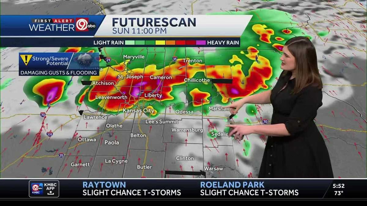
MONARCHS LOSE THIS ONE 8 TO 5. STILL A FUN GAME THOUGH. NEAT TO SEE. OKAY, BACK AND THE NEED TO KNOW THAT HE’S DOING SO WELL. NO SURPRISE. YEAH. AND OH MAN, PROBABLY WAS VERY HOT AT THAT GAME. I WAS AT THE GREAT LENEXA BARBECUE BATTLE YESTERDAY AND EVERYONE WAS JUST DRIPPING IN SWEAT. VERY HOT CONDITIONS. IF YOU HAVE ANY PLANS THIS WEEKEND, PREPARE FOR THE HEAT BECAUSE TODAY AND TOMORROW LOOKING HOT AND HUMID WITH FEELS LIKE TEMPERATURES IN THE MID TO UPPER 90S NOW, TOMORROW IS AN IMPACT DAY BECAUSE RAIN WILL IMPACT YOUR PLANS. WE HAVE SCATTERED RAIN IN THE MORNING AND THEN LATE IN THE DAY THE CHANCE FOR STRONG, MAYBE EVEN A FEW SEVERE THUNDERSTORMS. SO LET’S START WITH OUR IMPACT DAY TOMORROW AS WE GET INTO THE EARLY MORNING HOURS. REALLY, ANY TIME AFTER MIDNIGHT TONIGHT INTO EARLY SUNDAY MORNING, THAT’S WHEN WE’LL START TO SEE SCATTERED SHOWERS. FIRST ON THE KANSAS SIDE, MAKING THEIR WAY. EVENTUALLY ON THE MISSOURI SIDE, EVEN A FEW NON-SEVERE STORMS. SO THE FIRST HALF OF THE DAY, WE ARE NOT EXPECTING SEVERE WEATHER IN AND AROUND THE KANSAS CITY VIEWING AREA. JUST NORMAL SHOWERS AND STORMS MOVING THROUGH AND THEN DRYING OUT A LITTLE BIT AS WE HEAD INTO THE EARLY AFTERNOON AND EVENING HOURS. BY THE LATE EVENING HOURS, THIS IS WHEN WE COULD SEE A COLD FRONT MOVING THROUGH, FIRING UP STRONG, MAYBE EVEN SEVERE THUNDERSTORMS. IT’S GOING TO PRESS SOUTHWARD OUT OF NEBRASKA AND IOWA, AND AS IT DOES, WE’LL START TO SEE THOSE THUNDERSTORMS FIRING UP ALONG THAT COLD FRONT. NOW, WITH THAT SAID, DAMAGING WIND GUSTS ARE OUR BIGGEST CONCERN, BUT ALSO FLOODING CONSIDERING WE ALREADY HAVE HIGH RIVER AND CREEK LEVELS. SO THAT WILL BE A BIG CONCERN AS WE COULD SEE SOME HEAVY RAIN AND DOWNPOURS AS THOSE STORMS MOVE THROUGH TOMORROW EVENING AND NIGHT. BUT TODAY WE’RE LIKELY STAYING ON THE DRY SIDE. IT’S AN ISOLATED CHANCE FOR A POP UP SHOWER OR STORM. MOST OF US MISSING OUT ON THAT. JUST A MIX OF SUN AND CLOUDS FOR TODAY. 86 BY 12:00. OUR HIGH TODAY RIGHT AROUND 91 DEGREES WITH FEELS LIKE TEMPERATURES. LIKE I SAID IN THE MID TO UPPER 90S. SO IT WILL BE ON THE HOT SIDE FOR TODAY. ALSO PRETTY HOT FOR THAT SUNDAY FORECAST. WE’LL START OFF TOMORROW MORNING 73 DEGREES. AND IN TERMS OF THAT SEVERE THREAT, YES, THE GREATER RISK, THE SLIGHT RISK IS REALLY UP TO OUR NORTH IN IOWA. BUT WE STILL HAVE THE CHANCE. VERY LOW RISK FOR MAYBE A FEW STRONG TO SEVERE STORMS. THAT’S WHAT WE’RE TALKING ABOUT IT TO MAKE SURE YOU ARE WEATHER AWARE FOR TOMORROW EVENING AND NIGHT. FEW OF THOSE STORMS LINGER INTO MONDAY MORNING, BUT WE DRY OUT FOR A GOOD PORTION OF YOUR MONDAY AND STAY COOL. 86 DEGREES. THAT’S THAT COOLER AIR WIND OUT OF THE NORTH. WE STAY NICE AND REFRESHING. SEASONAL FOR THIS TIME OF YEAR INTO TUESDAY, 87 DEGREES OVERNIGHT LOWS. EVEN BACK IN THE MID 60S. THIS IS SEASONAL THIS TIME OF YEAR. OUR NORMAL HIGH 87. NORMAL LOW 67. SO DEFINITELY LOOKING FANTASTIC MONDAY TUESDAY A LITTLE BIT OF A BREAK FROM THAT 90 DEGREE STRETCH WE’VE HAD. BUT WE ARE BACK TO THE 90S. AS SOON AS WEDNESDAY. THURSDAY DRY BOTH DAYS. DRY RIGHT NOW FOR 4TH OF JULY 92 DEGREES AND THEN NEXT WEEKEND RAIN CHANCES RETURN OVERNIGHT LOWS IN THE 70S. HIGHS IN THE 90S. AND I MENTIONED THAT STRETCH OF 90S. HERE WE ARE WRAPPING UP THE MONTH OF JUNE. AND WE STARTED OFF WITH SOME BELOW NORMAL DAYS. AND THEN WE HIT THE 20S AND WE STAYED IN THE 90S AND STILL HAVE REACHED THOSE 90S EVEN THROUGH YESTERDAY, WILL LIKELY HIT IT AGAIN FOR TODAY. BUT AS WE JUST SAW MONDAY, TUESDAY, THAT’S WHEN THAT FRONT MOVES THROUGH, SWITCHING OUR WIND OUT OF THE NORTH, COOLING US DOWN SEASONAL WEATHER BACK IN THE 80S, JUST IN TIME
Quiet & hot today, but rain returns to KC tomorrow
Hot today with a mix of sun and clouds. There’s a small chance for a few pop-up storms, but better rain chances return tomorrow.

Calm & warm start to the weekend this Saturday morning. Temperatures are in the 60-70s with mostly clear skies. We’ll see a mix of sun and clouds today with highs in the upper 80s and low 90s. Feels like temperatures will easily reach the mid to upper 90s, so make sure to stay cool today. There’s a slim chance for a few pop-up isolated showers/storms today, but most will remain to the south of I-70. Better rain chances arrive in KC overnight tonight. Scattered showers and storms move in after midnight and linger into the first half of Sunday. Stronger storms, maybe even severe, arrive Sunday evening and night. The biggest concerns will be damaging wind gusts and flooding. As a result, Sunday is an Impact Day so plan accordingly and expect rain at times. Cooler air moves in for Monday and Tuesday thanks to a cold front that changes our wind direction back out of the north. Highs will be seasonal in the upper 80s for a few days, but 90s return to finish off the week!
Calm & warm start to the weekend this Saturday morning. Temperatures are in the 60-70s with mostly clear skies. We’ll see a mix of sun and clouds today with highs in the upper 80s and low 90s. Feels like temperatures will easily reach the mid to upper 90s, so make sure to stay cool today. There’s a slim chance for a few pop-up isolated showers/storms today, but most will remain to the south of I-70. Better rain chances arrive in KC overnight tonight. Scattered showers and storms move in after midnight and linger into the first half of Sunday. Stronger storms, maybe even severe, arrive Sunday evening and night. The biggest concerns will be damaging wind gusts and flooding. As a result, Sunday is an Impact Day so plan accordingly and expect rain at times. Cooler air moves in for Monday and Tuesday thanks to a cold front that changes our wind direction back out of the north. Highs will be seasonal in the upper 80s for a few days, but 90s return to finish off the week!
Leave a Reply