
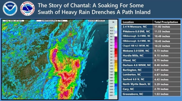
In the wake of Tropical Storm Chantal, which produced heavy rain that triggered flash flooding in the Carolinas, additional ripples in the atmosphere will produce more pop-up showers and severe thunderstorms in the East, which will tend to regulate the heat but boost humidity levels and continue the flash flood risk.
Chantal dropped up to a foot of rain on eastern North Carolina before picking up forward speed with progressively less rainfall in the coastal mid-Atlantic.

AccuWeather.com
Into Tuesday evening, daytime heating and a front moving into the region will continue to set off periodic showers, thunderstorms and localized severe weather from parts of New England to the Carolinas.

AccuWeather.com
The main focus of Tuesday’s storms will be an area stretching from northern Virginia and the eastern shore of Maryland to southeastern New York and southwestern Connecticut. AccuWeather meteorologists have issued a moderate risk of severe weather in this zone due to the greater concentration of storms capable of triggering major travel disruptions from powerful wind gusts and torrential downpours.

AccuWeather.com
Moving forward through the middle and latter parts of this week, the main threat from the ongoing, nearly daily rounds of thunderstorms in some areas will be flash flooding, especially where it rained hard the day before, saturated the ground and pushed small stream levels up.

AccuWeather.com
The downpours will tend to mitigate the heat, as some of the sun’s energy will be used to dry out the ground and set off the storms.
If an area of high pressure nearby were stronger, there would be less thunderstorm activity and much higher temperatures over a broad area this week.

AccuWeather.com
Correspondingly, where downpours miss a particular region daily, temperatures can climb to every degree possible with highs well into the 90s F. This is most likely over portions of the interior Carolinas and Georgia. However, temperatures will spike into the 90s in the mid-Atlantic on Tuesday, in the wake of Chantal and ahead of the weak front. That is, before thunderstorms erupt.
Want next-level safety, ad-free? Unlock advanced, hyperlocal severe weather alerts when you subscribe to Premium+ on the AccuWeather app. AccuWeather Alerts™ are prompted by our expert meteorologists who monitor and analyze dangerous weather risks 24/7 to keep you and your family safer.
Leave a Reply